Posts

Showing posts with the label information

How digitalization will help property owners

Image
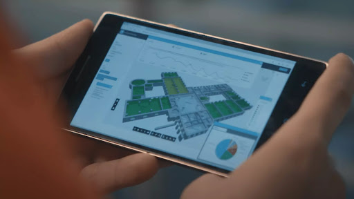
  Introduction The world is changing fast. Technology is advancing at a rapid pace and the internet of things (IoT) is making it possible to connect everything in our homes, cars, and offices to digital devices. We are also seeing more and more buildings being connected through smart building systems or using digital platforms for communication between people, buildings, and services. In this article, we will explore how property owners can leverage technology to improve their operations through the use of  digital twins : virtual representations of physical assets that are either created by software applications or based on existing data sets. It starts with creating a digital twin of the building or a whole portfolio. The first step is to create a digital twin of your building or portfolio. A digital twin is a model that captures the physical and functional characteristics of an asset, such as its size, shape, and location. This can be done using different methods: capture p...

The Ultimate Guide to BIM MEP Modelling for US Subcontractors

Image
  Introduction Construction subcontractors are a critical part of the  BIM  process. They fill the gaps that general contractors and designers cannot, either because of capacity issues or because of regulatory requirements. However, many subcontractors struggle to adopt BIM processes effectively. The majority of construction subcontractors do not have in-house CAD operators and 3D modelers. They tend to focus on niche areas within their sector, such as plumbing or electrical contracting. Thus, when working with a general contractor on a new project, they need to find another subcontractor to take on modeling responsibilities for their part of the build process. General contractors can’t provide detailed engineering drawings as part of their service offering. In addition, most general contractors won’t share proprietary data with an external third party due to competitive pressures and liability concerns. Therefore, if you are a BIM-savvy sub-contractor who wants to work o...

Steps to Create Digital Twin for your Building facility

Image
  Plan the Site We first take initial plans and mark all the areas which need to be scanned and create a schedule of scan and the pathway for the scanning activity, this process helps us in planning the scanning activity efficiently and capturing maximum  information  during the site survey. The number of scan points depends upon the clear sight of view, if there are more partitions or obstructions generally the number of scan points will increase, also in some of the spaces where ceilings must be removed to capture the above-ceiling services. Scan the Area After the planning, our team of site surveyors will visit the factory to scan to the factory layout during this process, our team will be carrying the TLS units along with manual measurement and georeferencing devices to scan and calibrate the data, the schedule of the scanning depends on the size and sight of clear view in the area, if there are more obstructions, naturally the number of scans will increase. Generally...

What COP 27 means for real estate and NetZero

Image
  What COP 27 means for real estate and NetZero As the world leaders meet in Egypt for COP 27, the 27th meeting of the parties to the United Nations Framework Convention on Climate Change (UNFCCC) treaty, it is important to remember that climate change is still a pressing issue. The Earth is going through a lot of changes, and it is happening faster than we thought it would. The ice caps are melting, sea levels are rising, and we are seeing more extreme weather events. We need to find ways to reduce our greenhouse gas emissions, and this is something that world leaders need to discuss at this meeting. They need to find ways to finance the transition to a low-carbon economy and they need to come up with a plan to implement these changes. This meeting is important, and we need to make sure that world leaders act on climate change. Global leaders are meeting today to discuss the terms of the collective effort to mitigate, finance, and adapt to climate change. The goal of this meeting ...

The Ultimate Guide for 3D Laser Scanning Companies

Image
  What is 3D laser scanning and what are its benefits for businesses and consumers alike Lidar, or Light Detection and Ranging, is a remote sensing technology that uses laser light to create detailed 3D maps/models of an area. Lidar systems are often used for surveying and engineering applications, as they can quickly and accurately collect data about the shape and contours of an area.  BIM , or Building Information Modelling, is a popular application for lidar data. BIM software allows architects and engineers to create virtual models of proposed buildings or structures, allowing for accurate assessment of construction projects.  Lidar  data can also be used by businesses and consumers to create 3D models of their homes or office space. These models can be used for base build contractors, interior design, Process plants, oil refineries, chemical plants, heavy industrial corridors, and Factories to get a better understanding of the layout of a space. In general,...

LOD in BIM, What Is It? How it is going to add value to your Construction Projects

Image
  Introduction Building Information Modelling (BIM) implementation is consequently challenging, challenges include unstructured data and processes that often lead to time and cost overruns. Having clarity on up to what level of geometry has to be modeled and how much information should include plays an important role in any project which directly affects the time and cost. At this point, LOD comes into the picture, gives clarity, clears many doubts, and sets standard expectations. What is LOD? Level of Detail or Level of Development (LOD) is a theoretical concept to support model development. The idea is that you attach a LOD status attribute to objects in conjunction with standardized reusable checklists. Thus you can, with increased certainty, guarantee a certain quality of  information  at a given point. LOD differs between geometry and properties. A model can be well developed through geometry without having much information concerning the properties of the model. In ...

Steps Towards Digitalization of Property

Image
  Introduction "Digitalization" is a trending aspect across industries due to its numerous benefits. The AEC industry is one of the good examples where many of the traditional processes of the Construction process are moving towards the adoption of the latest technologies to achieve efficiency. Digitalization of buildings refers to the conversion of all existing information of properties into digital formats and utilizing it to solve business problems and provide optimum solutions. About Digitalization is advancing the as-built/under-construction properties to smarter sites using  Digital Technologies  in the Digital World, which further makes the workflows, and processes easier and more effective. Digitalization is becoming a key aspect & these Digital models are generated from the geometrical and non-geometrical information acquired during the design and development stage of construction or from the  Laser Scanning  technique. The most common use cases of...